Epirus (region)
Epirus is a geographical and historical region in southeastern Europe, currently divided between the periphery of Epirus in northwestern Greece and the prefectures of Gjirokastër, Vlorë, Berat, and Korçë in southern Albania.
Contents |
Name & Etymology
The name Epirus comes from Greek: Ἤπειρος Epeiros (in Doric Greek and the native Northwestern Greek Ἅπειρος Apeiros), meaning "mainland".[1] It is thought to come from an Indo-European root *apero- 'coast'.[2] It was originally applied to the mainland opposite Corfu and the Ionian islands.[3] The Albanian name for the region is Epiri, deriving from the Greek.
Boundaries and definitions
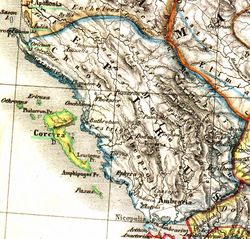
The historical region of Epirus is generally regarded as extending from the northern end of the Ceraunian mountains (modern-day Llogara, in present-day Albania), located just south of the Bay of Aulona (modern-day Vlorë), to the Ambracian Gulf (or Gulf of Arta) in Greece. The northern boundary of Classical Epirus is alternatively given as the mouth of the Aoos (or Vjosë) river, immediately to the north of the Bay of Vlorë.[4] Epirus' eastern boundary is defined by the Pindus Mountains that form the spine of mainland Greece and separate Epirus from Macedonia and Thessaly. To the west, Epirus faces the Adriatic Sea and Ionian Sea. The island of Corfu is situated off the coast but is not regarded as part of Epirus.
The definition of Epirus has changed over time, such that modern administrative boundaries do not correspond to the boundaries of classical Epirus. The Periphery of Epirus in Greece only comprises a fraction of classical Epirus and does not include the easternmost portions of classical Epirus, which lie in the periphery of Thessaly. In Albania, where the concept of Epirus is never used in an official context, the counties of Gjirokastër, Vlorë, Berat, and Korçë extend well beyond the northern and northeastern boundaries of classical Epirus.
Geography and ecology
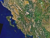
Epirus is a predominantly rugged and mountainous region. It is largely made up of the Pindus Mountains, a series of parallel limestone ridges that are a continuation of the Dinaric Alps. The Pindus mountains form the spine of mainland Greece and separate Epirus from Macedonia and Thessaly to the east. Altitude increases as one moves away from the coast, reaching a maximum of 2637m at Mount Smolikas, the highest point in Epirus. Other important ranges include, Tymfi (2496 at Mount Gamila), Lygkos (2249m), to the west and east of Smolikas, respectively, Gramos (2523m) in the northeast, Tzoumerka (2356m) in the southeast, Tomaros (1976m) in the southwest, Mitsikeli near Ioannina (1810m), Mourgana (1806m) and Nemercke/Aeoropos (2485) on the border between Greece and Albania, and Llogara (2000m) near Himara in Albania. Most of Epirus lies on the windward side of the Pindus. The winds from the Ionian Sea make the region the rainiest in Greece.
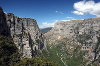
The main river flowing through Epirus is the Vjosë (Aoos in Greek), which flows in a northwesterly direction from the Pindus mountains in Greece to its mouth north of the Bay of Vlorë. Other important rivers include the Acheron river, famous for its religious significance in ancient Greece and site of the Necromanteion, the Arachthos river, crossed by the historic Bridge of Arta, the Thyamis river (aka Kalamas river), and the Voidomatis, a tributary of the Vjosë flowing through the spectacular Vikos Gorge. The Vikos Gorge forms the centerpiece of the Vikos-Aoos National Park, known for its scenic beauty. The only significant lake in Epirus is Lake Pamvotis, on whose shores lies the city of Ioannina, the largest city in Epirus and the seat of the Periphery of Epirus.
The climate of Epirus is mainly alpine in the interior and mediterranean along the coast. Epirus is heavily forested, mainly by coniferous species. The fauna in Epirus is especially rich and features species such as bears, wolves, foxes, deer and lynxes.
History
Early History
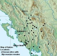
Epirus has been occupied since at least Neolithic times, when hunters and shepherds inhabited the region and constructed large tumuli to bury their leaders.[5] These tumuli bear many similarities to [6] Mycenean tombs,[7] indicating an ancestral link[8][9] between Epirus[10] and the Mycenean civilization.[11][12] A number of Mycenean remains have been found[13][14] in Epirus, especially at the most important ancient religious sites in the region, the Necromanteion (Oracle of the Dead) on the Acheron river, and the Oracle of Zeus at Dodona.[11]
In Middle Bronze Age, Epirus was settled by the same nomadic Hellenic tribes that went on to settle the rest of Greece.[15][16] By the early 1st millennium BC, the population of Epirus consisted of three principal clusters of Greek-speaking tribes[17]. These were the Chaonians in northwestern Epirus, the Molossians in the centre and the Thesprotians in the south.
Epirus in the Classical period
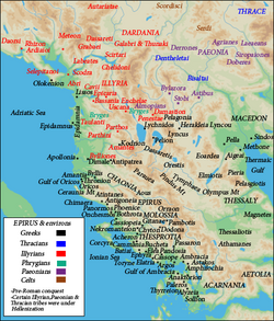
Unlike most other Greeks of this time, who lived in or around city-states such as Athens or Sparta, the Epirotes lived in small villages and their way of life was foreign to that of the polis of southern Greece.[18] Their region lay on the edge of the Greek world and was far from peaceful; for many centuries, it remained a frontier area contested with the Illyrian peoples to the north. However, Epirus had a far greater religious significance than might have been expected given its geographical remoteness, due to the presence of the shrine and oracle at Dodona - regarded as second only to the more famous oracle at Delphi.
The Epirotes, though apparently speakers of a Northwest Greek dialect, different from the Dorian of the Greek colonies on the Ionian islands, and bearers of mostly Greek names, as evidenced by epigraphy, seem to have been regarded with some disdain by some classical writers. The 5th century BC Athenian historian Thucydides describes them as "barbarians",[19] as does Strabo.[20] Other writers, such as Herodotus,[21] Dionysius of Halicarnassus[22] Pausanias[23] and Eutropius,[24] describe them as Greeks. Similarly, Epirote tribes/states are included in the Argive and Epidaurian lists of the Greek Thearodokoi (hosts of sacred envoys).[25] Plutarch mentions an interesting element of Epirote folklore regarding Achilles: In his biography of King Pyrrhus, he claims that Achilles "had a divine status in Epirus and in the local dialect he was called Aspetos" (meaning unspeakable, unspeakably great, in Homeric Greek).[26][27]
Beginning in 370 BC, the Molossian Aeacidae dynasty built a centralized state in Epirus and began expanding their power at the expense of rival tribes. The Molossians allied themselves with the increasingly powerful kingdom of Macedon, and in 359 BC the Molossian princess Olympias, niece of Arybbas of Epirus, married King Philip II of Macedon. She was to become the mother of Alexander the Great.
On the death of Arybbas, Alexander of Epirus succeeded to the throne and the title King of Epirus. Aeacides of Epirus, who succeeded Alexander, espoused the cause of Olympias against Cassander, but was dethroned in 313 BC. His son Pyrrhus came to throne in 295 BC, and for six years fought against the Romans and Carthaginians in southern Italy and Sicily. The high cost of his victories against the Romans gave Epirus a new, but brief, importance, as well as a lasting contribution to the Greek language with the concept of a "Pyrrhic victory".
In the 3rd century BC, Epirus remained a substantial power, unified under the auspices of the Epirote League as a federal state with its own parliament, or synedrion. However, it was faced with the growing threat of the expansionist Roman Republic, which fought a series of wars with Macedonia. The League remained neutral in the first two Macedonian Wars but split in the Third Macedonian War (171 BC-168 BC), with the Molossians siding with the Macedonians and the Chaonians and Thesprotians siding with Rome. The outcome was disastrous for Epirus; Molossia fell to Rome in 167 BC, 150,000 of its inhabitants were enslaved, and the region was so thoroughly plundered that it took 500 years for central Epirus to recover fully.
Roman and Byzantine rule
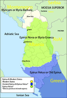
The Roman invasion permanently ended the political independence of the Epirotes. In 146 BC, Epirus became part of the province of Roman Macedonia, receiving the name Epirus vetus, to distinguish it from Epirus nova to the north. Its coastal regions grew wealthy from the Roman coastal trade routes, and the construction of the Via Egnatia provided a further boost to prosperity.
When the Roman Empire was divided in two in 395 AD, Epirus became part of the Eastern Roman Empire (subsequently the Greek-speaking Byzantine Empire), ruled from Constantinople. In the 7th century, much of the region was settled by migrating Slavic tribes; the tribe of the Vaiounitai (mentioned in the Greek Miracles of St. Demetrius) may have settled in and given their name to Vagenetia[28] the coastal part of Epirus roughly from Himara in the north to Margariti in the south. Byzantine control of that part of Epirus began to strengthen only two centuries later. A Vlach presence in Epirus is first mentioned in the Strategikon of Kekaumenos (late 11th century).
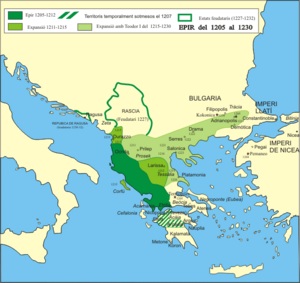
When Constantinople fell to the Fourth Crusade in 1204, Michael Angelos Komnenos Ducas seized Aetolia and Epirus and established an independent state known as the Despotate of Epirus. The rulers of the Despotate controlled a substantial area corresponding to a large swathe of northwestern Greece, much of modern Albania and parts of the modern Republic of Macedonia. During this time, the definition of Epirus came to encompass the entire coastal region from the Ambracian Gulf to Dyrrachium (modern-day Durrës, in Albania). Some of the most important cities in Epirus, such as Gjirokastër (Argyrokastron), were founded during this period.
In 1348, Epirus was attacked by Serbs, with a number of Albanian clans assisting them. The Byzantine authorities in Constantinople soon re-established a measure of control by making the despotate a vassal state, but meanwhile Albanian clans settled in parts of the region and founded two local, short-lived entities, centered in Arta (1358–1416) and Gjirokastër (1386–1411) by Liosha and Zenebishi clans respectively. Although Albanian clans gained control of most of the region of Epirus by 1366-7, they didn't replace any Greek or Serbian central authority in the region but remained divided in clans.[29] After the death of Carlo I Tocco he left control of the remaining areas of the Despotate of Epirus to his nephew Carlo II Tocco. but his illigitemate sons allied with the Ottomans to overthrow him. In October 1430 the capital of the Despotate Ioannina surrendered on demand to the Ottomans and received a charter of privileges. In 1431 the Ottomans conquered the other areas of the Despotate except Arta, but allowed Carlo II Tocco to keep it as an Ottoman vassal. In 1449 they annexed Arta excluding the dominions of Venice after expelling Leonardo III Tocco, son of Carlo II Tocco.[30]
Ottoman rule
.JPG)
| Greek speakers Greek and Vlach speakers Greek and Albanian speakers Albanian speakers | Greek Orthodox entirely Greek Orthodox majority Greek Orthodox - Muslim equivalence Muslim majority Muslim entirely |
Epirus was ruled by the Ottomans for almost 500 years. Ottoman rule in Epirus proved particularly damaging; the region was subjected to deforestation and excessive cultivation, which damaged the soil and drove many Epirotes to emigrate so as to escape the region's pervasive poverty. Nonetheless, the Ottomans did not enjoy total control of Epirus. The Himara region managed to successfully resist Ottoman rule and maintained a degree of independence throughout this period. In 1443, the northernmost part of Epirus was briefly conquered by Gjergj Kastrioti Skenderbeg as part of his revolt against the Ottoman Empire, but on his death it fell to Venice. The Ottomans expelled the Venetians from almost the whole area in the late 15th century.
In the 18th century, as the power of the Ottoman Empire declined, Epirus became a de facto independent region under the despotic rule of Ali Pasha of Tepelena, an Albanian brigand who rose to become the provincial governor of Ioannina in 1788. At the height of his power, he controlled much of western Greece, the Peloponnese, and southern Albania. Ali Pasha's campaign to subjugate the confederation of the settlements of Souli is a well known incident from his rule. His forces met fierce resistance by the Souliot warriors of the mountainous area. After numerous failed attempts to defeat the Souliotes, his troops succeeded in conquering the area in 1803. When the Greek War of Independence broke out, the inhabitants of Epirus contributed greatly. Two of the founding members of the Filiki Eteria (the secret society of the Greek revolutionaries), Nikolaos Skoufas and Athanasios Tsakalov, came from the Arta area and the city of Ioannina, respectively. Greece's first constitutional prime minister (1844–1847), Ioannis Kolettis, was a native of the Vlach Greek village of Syrrako in Epirus and was a former personal physician to Ali Pasha. Ali Pasha tried to use the war as an opportunity to make himself a fully independent ruler, but was assassinated by Ottoman agents in 1822.
When Greece became independent in 1830, however, Epirus remained under Ottoman rule. In 1854, during the Crimean War, a major local rebellion broke out. Although the newly found Greek state tried tacitly to support it, the rebellion was suppressed by Ottoman forces after a few months.[31] Another failed rebellion by local Greeks broke out in 1878. Throughout, the late period of Ottoman rule (from 18th century) Greek and Aromanian population of the region suffered from Albanians raiders, that sporadically continued after Ali Pasha's death, until 1913.[32]
20th century Epirus
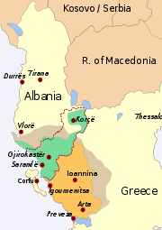 |
| The region of Epirus in the 20th century, divided between Greece and Albania.
Grey: approx. extent of Epirus in antiquity; Orange: Greek periphery of Epirus; Green: approx. extent of largest concentration of Greeks in "Northern Epirus", early 20th cent.[33] Red dotted line: Territory of Autonomous State of Northern Epirus |
The Treaty of Berlin of 1881 gave parts of southern Epirus to Greece, but it was not until the First Balkan War of 1912–13 and the Treaty of London[34] that the rest of southern Epirus joined Greece. The Treaty of Bucharest, which concluded the Second Balkan War, gave Northern Epirus to Albania.[35]
This outcome was unpopular among both Greeks and Albanians, as settlements of the two people existed on both sides of the border. Among Greeks, northern Epirus was regarded as terra irredenta. When World War I broke out in 1914, Albania collapsed. Under a March 1915 agreement among the Allies, Italy seized northern Albania and local Greeks revolted and after fierce guerilla fighting managed to set up an officially autonomous state in Northern Epirus in the southern part of the country. Although short-lived, the Autonomous Republic of Northern Epirus managed to leave behind a number of historical records of its existence, including its own postage stamps; see Postage stamps and postal history of Epirus.
Although the Paris Peace Conference of 1919 awarded Northern Epirus to Greece, developments such as the Greek defeat in the Greco-Turkish War and, crucially, Italian lobbying in favor of Albania meant that Greece would not keep Northern Epirus. In 1924, the area was again ceded to Albania.
In 1939, Italy occupied Albania, and in 1940 invaded Greece. The Italians were driven back into Albania, however, and Greek forces again took control of northern Epirus. The conflict marked the first tactical victory of the Allies in World War II. Benito Mussolini himself supervised the massive counter-attack of his divisions in spring 1941, only to be decisively defeated again by the poorly equipped, but determined, Greeks. Nazi Germany then intervened in April 1941 to avert an embarrassing, wholesale Italian defeat. The German military performed rapid military maneuvers through Yugoslavia and forced the encircled Greek forces of the Epirus front to surrender.
The whole of Epirus was then placed under Italian occupation until 1943, when the Germans took over following the Italian surrender to the Allies. Due to the extensive activity of the anti-Nazi Greek resistance (mainly under EDES), the Germans carried out large scaled anti-partisan sweeps, making wide use of the Albanian Nazi-collaborationist bands of Cham Albanians, who committed numerous atrocities against the civilian population.[36]
To deal with the situation, the Allied Military Mission in the Axis-occupied Greece (under Colonel C.M. Woodhouse), gave EDES partisans direct orders to counter-attack and chase out of their villages those units that used them as bases and local strongholds. Helped by Allied war material transferred from the recently liberated southern Italy, EDES forces succeeded and as a result several thousands Muslim Cham Albanians fled the area and took refuge in the nearby Albania.
With the liberation of Greece and the start of the first round of the Greek Civil War at the end of 1944, the highlands of Epirus became a major theatre of guerilla warfare between the leftist National People's Liberation Army (ELAS) and the right-wing National Republican Greek League (EDES). In subsequent years (1945–1949), the mountains of Epirus also became the scene of some of the fiercest fighting of the second and bloodier round of the Greek Civil War. The final episode of war took place on Mount Grammos in 1949, ending with the defeat of the Communists. Peace returned to the region in 1949, although because of official Albanian active involvement in the civil war on the side of the communists, the formal state of war between Greece and Albania remained in effect until 1987. Another reason for the continuation of the state of war until 1987 was that during the entire period of Communist rule in Albania, the Greek population of Northern Epirus experienced forced Albanisation.[37]
The collapse of the communist regime in Albania in 1990-1991 triggered a massive migration of Albanian citizens to Greece, which included many members of the Greek community of Northern Epirus. Since the end of the Cold War, many Greeks in Northern Epirus are re-discovering their Greek heritage thanks to the opening of Greek schools in the region, while Cham Albanians have called for compensation for their lost property.
Gallery
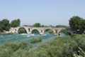 The renowned Bridge of Arta. |
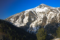
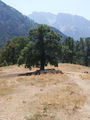
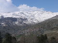 The village of Aetomilitsa on Mount Gramos, in the Pindus mountains. |
 The Vikos river, Vikos-Aoos National Park. |
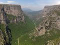 The spectacular Vikos Gorge. |
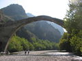 The old bridge of Konitsa over the Aoos river. |
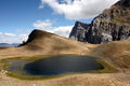 The high altitude Lake Drakolimni (Dragon Lake), on Mount Gamila in the Pindus mountains. |
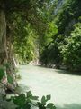 A canyon of the Acheron river. |
 The city of Ioannina, the largest city in Epirus and seat of the periphery of Epirus. |
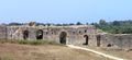 The walls of ancient Nicopolis. |
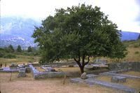
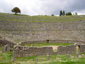 The Hellenistic theater of Dodona. |
 Sheep under the shade of a tree near Konitsa. |
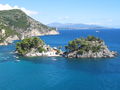 The bay of Parga. |
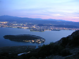
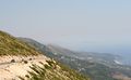 The region of Himara seen from the Llogara pass. |
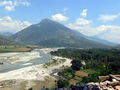 The Aoos or Vjosa river near Tepelena. |
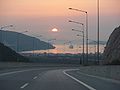 Section of the Egnatia Odos, the only freeway in Epirus, near Igoumenitsa. |
See also
- Ancient Epirus: Molossians, Thesprotians, Chaonians, Dodona, Pyrrhus of Epirus
- Despotate of Epirus
- Despotate of Arta
- Northern Epirus: Northern Epirotes, Autonomous Republic of Northern Epirus, Protocol of Corfu
- Cham Albanians, Chameria
- Greco-Italian War
- Souliotes
- Himara
- Ioannina
- Pindus Mountains
- Epirus (periphery) in Greece
- Vikos-Aoos National Park
- List of Epirotes
References
- ↑ Epeiros, Henry George Liddell, Robert Scott, A Greek-English Lexicon, at Perseus
- ↑ Babiniotis, G. Lexiko tis Neas Ellinikis Glossas. Athens, 1998.
- ↑ WinnifrIth, T.J. Badlands-Borderland: A History of Southern Albania/Northern Epirus. London: Duckworth Publishers, 2003. "...classical times Epirus was a name for the mainland opposite Corfu and the other Ionian islands"
- ↑ John Wilkes. The Illyrians. Wiley-Blackwell, 1996, p. 92. "Appian's description of the Illyrian territories records a southern boundary with Chaonia and Thesprotia, where ancient Epirus began south of river Aoous (Vjose)." (Map)
- ↑ Tandy, David W. Prehistory and History: Ethnicity, Class and Political Economy. Black Rose Books Ltd., 2001, p. 27.
- ↑ Tandy, David W. Prehistory and History: Ethnicity, Class and Political Economy. Black Rose Books Ltd., 2001, p. 4.
- ↑ Tandy, David W. Prehistory and History: Ethnicity, Class and Political Economy. Black Rose Books Ltd., 2001, p. 6.
- ↑ Tandy, David W. Prehistory and History: Ethnicity, Class and Political Economy. Black Rose Books Ltd., 2001, p. 17.
- ↑ Tandy, David W. Prehistory and History: Ethnicity, Class and Political Economy. Black Rose Books Ltd., 2001, p. 18.
- ↑ Tandy, David W. Prehistory and History: Ethnicity, Class and Political Economy. Black Rose Books Ltd., 2001, p. 22.
- ↑ 11.0 11.1 Tandy, David W. Prehistory and History: Ethnicity, Class and Political Economy. Black Rose Books Ltd., 2001, p. 23.
- ↑ Tandy, David W. Prehistory and History: Ethnicity, Class and Political Economy. Black Rose Books Ltd., 2001, p. 24.
- ↑ Tandy, David W. Prehistory and History: Ethnicity, Class and Political Economy. Black Rose Books Ltd., 2001, p. 30.
- ↑ McHenry, Robert. The New Encyclopaedia Britannica. Encyclopaedia Britannica, 1993, p. 527. "Mycenean remains have been found at two religious shrines of great antiquity in the region."
- ↑ Borza, Eugene N. (1992). In the Shadow of Olympus: The Emergence of Macedon (Revised Edition). Princeton, New Jersey: Princeton University Press. "Speakers of these various Greek dialects settled different parts of Greece at different times during the Middle Bronze Age, with one group, the 'northwest' Greeks, developing their own dialect and peopling central Epirus. This was the origin of the Molossian or Epirotic tribes." "[...]a proper dialect of Greek, like the dialects spoken by Dorians and Molossians." "The western mountains were peopled by the Molossians (the western Greeks of Epirus)."
- ↑ Minahan, James. Encyclopedia of Stateless Nations. Greenwood Publishing Group, 2002, p. 578.
- ↑ Crew, P. Mack (1982). The Cambridge Ancient History - The Expansion of the Greek World, Eighth to Sixth Centuries B.C., Part 3: Volume 3 (Second Edition). Cambridge, UK: Cambridge University Press. "That the Molossians[...]spoke Illyrian or another barbaric tongue was nowhere suggested, although Aeschylus and Pindar wrote of Molossian lands. That they in fact spoke Greek was implied by Herodotus' inclusion of Molossi among the Greek colonists of Asia Minor, but became demonstrable only when D. Evangelides published two long inscriptions of the Molossian State, set up in 369 BC at Dodona, in Greek and with Greek names, Greek patronymies and Greek tribal names such as Celaethi, Omphales, Tripolitae, Triphylae, etc. As the Molossian cluster of tribes in the time of Hecataeus included the Orestae, Pelagones, Lyncestae, Tymphaei and Elimeotae, as we have argued above, we may be confident that they too were Greek-speaking."
- ↑ Hammond, N.G.L. Epirus. Oxford University Press, 1967.
- ↑ Thucydides. The History of the Peloponnesian War, Book I. (Internet Classics Archive). "The same summer, not long after this, the Ambraciots and Chaonians, being desirous of reducing the whole of Acarnania and detaching it from Athens, persuaded the Lacedaemonians to equip a fleet from their confederacy and send a thousand heavy infantry to Acarnania, representing that, if a combined movement were made by land and sea, the coast Acarnanians would be unable to march, and the conquest of Zacynthus and Cephallenia easily following on the possession of Acarnania, the cruise round Peloponnese would be no longer so convenient for the Athenians. Besides which there was a hope of taking Naupactus."
- ↑ Strabo. Geography. Book VII, 7.1. (LacusCurtius).
- ↑ Herodotus Histories 6.127
- ↑ Dionysius of Halicarnassus. Roman Antiquities. Book XX, 10.19.11. (LacusCurtius).
- ↑ Pausanias. Description of Greece, 1.11.7-1.12.2 (Theoi Project).
- ↑ Eutropius. Abridgment of Roman History (Historiae Romanae Breviarium) Book II, 11.13. (Tertullian)
- ↑ Davies, J.K. A Wholly Non-Aristotelian Universe: The Molossians as Ethnos, State and Monarchy in Alternatives to Athens: Varieties of Political Organization and Community in Ancient Greece. Oxford University Press, 2000, pp. 234-258.
- ↑ Cameron, Alan. Greek Mythography in the Roman World. Oxford University Press, 2004, p. 141. "As for Aspestos, Achilles was honored in Epirus under that name, and the patronymic [Ἀ]σπετίδης is found in a fragmentary poem found on papyrus."
- ↑ cf. Athenian secretary: Aspetos, son of Demostratos from Kytheros ~340 BC.
- ↑ M. Laskaris, Vagenetia, Revue Historique de Sud-Est Europeen 19 (1942), however, disputes this and situates the Vaiounitai in Macedonia
- ↑ Van Antwerp, John (1994). The Late Medieval Balkans: A Critical Survey from the Late Twelfth Century to the Ottoman Conquest. University of Michigan Press. pp. 348-51. ISBN 0472082604. http://books.google.com/?id=QDFVUDmAIqIC&pg=PA350&dq=Aetolia+1359&cd=1#v=onepage&q=Aetolia%201359.
- ↑ John Van Antwerp Fine, p.544
- ↑ Reid, James J. (2000). Crisis of the Ottoman Empire: Prelude to Collapse 1839-1878. Franz Steiner Verlag. ISBN 9783515076876.
- ↑ Hammond, Nicholas (1976). Migrations and invasions in Greece and adjacent areas. Noyes Press. p. 41. ISBN 0815550472. http://books.google.com/?id=_VBoAAAAMAAJ&dq=At+this+time+the+decline+of+the+Vlachs+was+completed%3B+for+example%2C+in+1854+Metsovo+was+captured+first+by+Greeks+and+then+by+Turks+and+plundered+by+both.&q=Throughout+this+period+bands+of+Albanians+raiders+pillaged+and+destroyed+the+villages+of+the+Vlachs+and+the+Greeks+in+Epirus%2C+northern+Pindus%2C+the+lakeland+of+Prespa+and+Ochrid%2C+and+parts+of+western+Macedonia.+One+Albanian+leader%2C+%27Ali+the+Lion%27%2C+emulated+the+achievements+of+%27John+the+Sword%27+and+%27Peter+the+Pockmark%27+when+he+established+himself+as+Ali+Pasha%2C+independent+ruler+of+Ioannina.+He+and+his+Albanian+soldiers%2C+recruited+mainly+from+his+homeland+in+the+Kurvelesh+and+the+Drin+valley+of+North+Epirus%2C+controlled+the+whole+of+Epirus+and+carried+their+raids+far+into+western+Macedonia+and+Thessaly.+As+we+have+seen%2C+they+destroyed+the+Vlach+settlements+in+the+lakeland+and+weakened+those+farther+south.+After+the+assassination+of+Ali+Pasha+in+1822+sporadic+raids+by+bands+of+Albanians+were+a+feature+of+life+in+northern+Greece+until+the+liberation+or+1912-13#search_anchor.
- ↑ Following G. Soteriadis: An Ethnological Map Illustrating Hellenism In The Balkan Peninsula And Asia Minor. London: Edward Stanford, 1918. File:Hellenism in the Near East 1918.jpg
- ↑ Clogg, Richard. Concise History of Greece 1770–2000. Cambridge University Press, 2002. "In February 1913 the Greek Army seized Ioannina, the capital of Epirus. The Turks recognized the gains of the Balkan allies by the Treaty of London, in May 1913."
- ↑ Clogg, Richard. Concise History of Greece 1770–2000. Cambridge University Press, 2002. "The Second Balkan War had short duration and the Bulgarians were soon dragged to the table of negotiations. By the Treaty of Bucharest (August 1913) Bulgaria was forced to accept a little favourable regulation of the borders, even if she kept a way to the Aegean, in Degeagatch (modern Alexandroupolis). The sovereignty of Greece on Crete was now recognised, but her ambition to annex Northern Epirus with its large Greek population was stopped by the annexation of the area to an independent Albania."
- ↑ Ruches, Pyrros (1965). Albania's Captives. Chicago, USA: Argonaut. pp. 162–167
- ↑ Pettifer, James. "The Greek Minority in Albania - In the Aftermath of Communism". Conflict Studies Research Centre, July 2001, ISBN 1-903584-35-3, p. 7.